
Spacecraft Data

Anaglyph of TAGSAM and Bennu During Checkpoint Rehearsal

REXIS Field Of View: Black Hole X-Ray Detection

REXIS Black Hole X-Ray Detection

OLA's Complete 3D Map of Bennu

Nightingale Stereo Pair

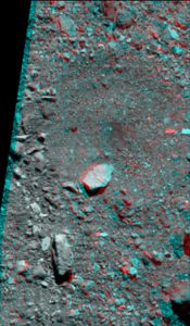
Nightingale Anaglyph

Nightingale Boulder Count - Northern Region

Nightingale Boulder Count - Central Region

Nightingale Boulder Count - 10 Meter Radius

Nightingale Boulder Count - 8 Meter Radius

Kingfisher Stereo Pair

Kingfisher Anaglyph

Kingfisher Boulder Map

Osprey Stereo Pair
Osprey Anaglyph

Osprey Boulder Count Map - West Region

Osprey Boulder Count Map - East Region

Sandpiper Stereo Pair

Sandpiper Anaglyph

Sandpiper Boulder Count Map

Bennu Thermal Map (Derived from Approach Data)

Bennu Visualized by OLA

75-cm Bennu Shape Model

Preliminary Bennu Shape Model (Nov. 2018)

OVIRS Spectral Curve Captured During OSIRIS-REx’s Earth Gravity Assist

OTES Spectral Curves Captured During OSIRIS-REx’s Earth Gravity Assist